
Category:Asia/Philippines/Corregidor Island/: Difference between revisions
No edit summary |
No edit summary |
||
| Line 7: | Line 7: | ||
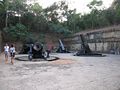
Image:Tomacruz-2009-07-08-07-51-30.JPG| | Image:Tomacruz-2009-07-08-07-51-30.JPG| | ||
Image:Tomacruz-2009-07-08-15-07-30.JPG|Docking Area | Image:Tomacruz-2009-07-08-15-07-30.JPG|Docking Area | ||
Image:Tomacruz-2009-07-08-15-10-05.JPG|Sunset at Corregidor | |||
</gallery> | </gallery> | ||
Revision as of 15:10, 8 July 2009
Corregidor Island
For the Spanish historical administrative position, see Corregidor (position)Corregidor is an island in the entrance of the Philippines' Manila Bay. Due to its position in the bay, it has served as a focal point for the naval defenses of the capital city of Manila. During World War II, Corregidor was the site of several battles and its fall to the Japanese forces was instrumental in the subsequent capture of the Philippines and the retreat of the United States in the early stages of the war. Currently, it is an important historic and tourist site and is managed under the jurisdiction of Cavite City.[1]
Gallery
-
-
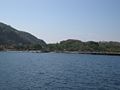 Docking Area
 -
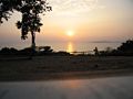 Sunset at Corregidor


References
- ↑ Corregidor Island Wikipedia.ORG. Accessed April 2009.
This category currently contains no pages or media.