
Category:Asia/Philippines/Cebu/Daanbantayan/Malapascua Island/: Difference between revisions
No edit summary |
No edit summary |
||
| (3 intermediate revisions by 3 users not shown) | |||
| Line 2: | Line 2: | ||
== Malapascua Island == | == Malapascua Island == | ||
[[Image:Malapascua-PHC.jpg|200 px|right|thumb|Philippine Hobie Challenge 6 in Malapascua Island]] | [[Image:Malapascua-PHC.jpg|200 px|right|thumb|Philippine Hobie Challenge 6 in Malapascua Island]] | ||
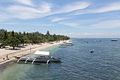
* (across the northernmost tip of Cebu). It was on Christmas day when the Spaniards reached the island. According to townfolks, it was supposed to be a special day of celebration but unfortunately a storm hit the island and so came the name “Malapacual”, Malas sa Pasko, which means “Unfortunate Christmas” in English. Malapascua is sometimes referred to as “Logon”, the main community in the south. “Logon” got its name when the Japanese and Americans fought over the island during WWII. The island is 3 km. long and 1 km. wide, with a population of about 3,000. It has white sand beaches and crystal clear waters. The west coast is ideal for swimming and snorkeling but one should be careful because of unpredictable weather. A walk or tour on the whole island can be done within half a day. | * (across the northernmost tip of Cebu). It was on Christmas day when the Spaniards reached the island. According to townfolks, it was supposed to be a special day of celebration but unfortunately a storm hit the island and so came the name “Malapacual”, Malas sa Pasko, which means “Unfortunate Christmas” in English. Malapascua is sometimes referred to as “Logon”, the main community in the south. “Logon” got its name when the Japanese and Americans fought over the island during WWII. The island is 3 km. long and 1 km. wide, with a population of about 3,000. It has white sand beaches and crystal clear waters. The west coast is ideal for swimming and snorkeling but one should be careful because of unpredictable weather. A walk or tour on the whole island can be done within half a day. | ||
| Line 10: | Line 11: | ||
* [http://www.travelsmart.net/article/101393/ Malapascua Island Misadventure] | * [http://www.travelsmart.net/article/101393/ Malapascua Island Misadventure] | ||
* [http://www.travelsmart.net/article/10000551/ Cebu Travel Guide] | * [http://www.travelsmart.net/article/10000551/ Cebu Travel Guide] | ||
* [http://www.ourawesomeplanet.com/awesome/2006/01/the_island_of_m.html The Charming Island of Malapascua!] | |||
[[Category:Asia/Philippines/Cebu/Daanbantayan/]] | |||
== Gallery == | |||
<gallery> | |||
Image:Malapascua_Main_Beach.jpg|Main Beach | |||
</gallery> | |||
[[Category:Asia/Philippines/Cebu/Daanbantayan/]] | [[Category:Asia/Philippines/Cebu/Daanbantayan/]] | ||
Latest revision as of 09:55, 24 May 2013
Malapascua Island

- (across the northernmost tip of Cebu). It was on Christmas day when the Spaniards reached the island. According to townfolks, it was supposed to be a special day of celebration but unfortunately a storm hit the island and so came the name “Malapacual”, Malas sa Pasko, which means “Unfortunate Christmas” in English. Malapascua is sometimes referred to as “Logon”, the main community in the south. “Logon” got its name when the Japanese and Americans fought over the island during WWII. The island is 3 km. long and 1 km. wide, with a population of about 3,000. It has white sand beaches and crystal clear waters. The west coast is ideal for swimming and snorkeling but one should be careful because of unpredictable weather. A walk or tour on the whole island can be done within half a day.
Articles

Gallery
-
 Main Beach

Pages in category "Asia/Philippines/Cebu/Daanbantayan/Malapascua Island/"
The following 9 pages are in this category, out of 9 total.
A
- Asia/Philippines/Cebu/Daanbantayan/Cocobana Beach Resort/
- Asia/Philippines/Cebu/Daanbantayan/Malapascua Island/Blue Coral Resort/
- Asia/Philippines/Cebu/Daanbantayan/Malapascua Island/Blue Water Resort/
- Asia/Philippines/Cebu/Daanbantayan/Malapascua Island/Hippocampus Resort/
- Asia/Philippines/Cebu/Daanbantayan/Malapascua Island/La Dolce Vita/
- Asia/Philippines/Cebu/Daanbantayan/Malapascua Island/Logon Church/
- Asia/Philippines/Cebu/Daanbantayan/Malapascua Island/Logon Resort/
- Asia/Philippines/Cebu/Daanbantayan/Malapascua Island/Logon School/
- Asia/Philippines/Cebu/Daanbantayan/Malapascua Island/Sunsplash Resort/